Harness the power of Blue Marble?s three geospatial data conversion toolkits ? all in one package! GeoCore gives software developers the coordinate transformation and definition powers GIS experts have come to rely on with the GeoCalc? library, plus the ability to handle all of your raster and vector file format and geometry needs with GeoTranslate? and GeoTransform?. One simple package and one easy to use interface!
Our 2012 release, has many new features. Read about them under the various developer tool pages. Each section has a 'What's New' area that will provide you with current information. Some of the highlights include:
New vertical height offset method, and support for eight new height models.
Accuracy measurements have been added to all datum transformations.
Support for larger LAS transformation and rendering
A new CAD to CAD converter supports block and cell preservation
Read on to learn more or Download your copy today!
GeoCalc 6.5 is the latest offering of our coordinate transformation "engine" that performs on-the-fly coordinate transformations as well as geodetic calculations. When used within any GIS, surveying, engineering, or mapping system, GeoCalc provides highly accurate and dependable geographic coordinate transformations and geodetic calculations. GeoCalc employs a high-level parametric database model to efficiently store and retrieve coordinate system, map projection, ellipsoidal, geodetic datum transformation, and unit parameters. If you care about highly accurate mapping, then GeoCalc is essential for your product or project.
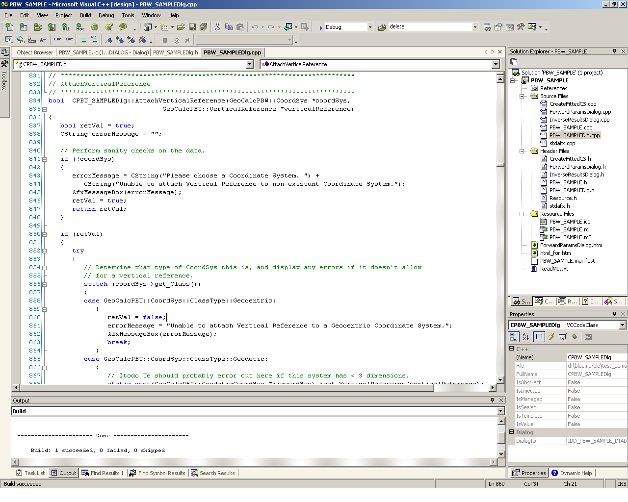
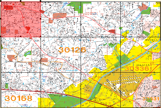
Blue Marble Desktop created with the tools in GeoCore
GeoTranslate 5.2 is the latest version of Blue Marble vector translation and manipulation technology. We have supported geometry based format translation for well over a decade in our Geographic Translator desktop software and our GeoObjects developer tool kit. GeoTranslate takes this to the next level with a cross platform C++ library that will seamlessly interact with GeoCalc and GeoTransform. With this toolkit, users can read and write many of today's most popular vector file formats. In the latest version, you can handle large LiDAR formatted datasets for vertical transformation and quick rendering. Users are also granted direct access to a wide variety of geometry objects, which can be created and manipulated on-the-fly. Along with these geometry objects, users are granted access to the metadata and attributes that are commonly associated with these geometries. Additionally this architecture makes it easy for users to write their own file format support out of the box.
When it comes to raster image file transformation, manipulation, and translation, GeoTransform 6.2 is the toolkit you need. With this library, users can read, write, compress, and manipulate many of today's standard GIS raster image file formats, including non-visual raster datasets such as DEMs, DTEDs, and raster binary grids. There is even functionality to render images to a standard Window handle. The SDK also adds powerful mosaicking and tiling capabilities to the single image transformation interface from previous releases. Clipping interfaces allow you to manage, manipulate, and process large datasets like never before.
Now combined into GeoCore, the features of these three software development kits give you an easy to use, affordable option to quickly create a robust spatial data management application that can work with both raster and vector data accurately.
Features
Geospatial Conversion, Translation and Transformation in One Software Development Kit
Harness the power of Blue Marble?s three geospatial data conversion toolkits ? all in one package! GeoCore gives software developers the coordinate transformation and definition powers GIS experts have to come to rely on with the GeoCalc? library, plus the ability to handle all of your raster and vector file format and geometry needs with GeoTranslate? and GeoTransform?. One simple package, and one easy to use interface! Now you can use whatever pieces you need, when you need them. GeoCalc, GeoTransform and GeoTranslate now reside in the same software development kit. Work seamlessly with all of the features of all three toolkits through a combined license. GeoCore will save your organization time, reduce errors and increase reliability of all your geospatial data.
Coordinate Conversion
The World's Most Comprehensive Coordinate Conversion Parameter Database
Over 12,000 coordinate system conversions are supported with pre-defined linear and angular units, ellipsoids, geodetic datums and coordinate systems. The latest update includes the new Pseudo Mercator (Google) coordinate system, and several updates to the Geodetic datasource. Plus, use our "two point fit" transformation and easy-to-use designers to create custom coordinate systems.
XML Data Source
Common Coordinate System Dialogs
Convert coordinates on a point-by-point or database basis as you issue GeoCore function calls. We have included several useful common coordinate system dialogs to accelerate your development!
Horizontal Time Dependent Positioning (HTDP)
Horizontal Time Dependent Positioning provides a means to predict and adjust for data transformations related to movements of the Earth's crust over time. HTDP time dependent shifts are now available through the GeoCalc datasource.
Alberta Township System (ATS) Support
The Alberta Township System (ATS) is a surveying system used in parts of Western Canada including Alberta Province. It is a variation of the Dominion Land Survey (DLS). Included is support for Alberta Township System legacy grids, versions 2.1-2.6, 3.1. 3.2 NAD27, 3.2 NAD83, and version 4.1. Your GeoCalc enhanced application can convert between the ATS system and any of our many geodetic or projected coordinate systems.
Tools for Improving Data Quality Management from a Development Level
Updated locking and signing features are available on the Datasource object. Datasource dialogs allow you to move, rename and hide columns. Viewfile classes make it much easier to create your own dialog, or organize the standard GeoCore dialogs. An updated change log allows for easy visualization of the Audit Trail tool.
Additional Features
You can define your own custom coordinate systems, datum, ellipsoid, and unit parameters.
Define your own custom datums based on Molodensky shifts or seven Bursa/Wolfe datum transformation parameters. GeoCalc also supports NADCON, U.S. HARN (enhanced NAD83), DMA Multiple Regression Equation, Canadian National Transformation coordinate transformations, the Molodensky-Badekas 10 Parameter Shift, Ordnance Survey National Grid Transform of 2002, Seven Parameter Helmert Shift, Six Parameter Helmert Shift, Four Parameter Helmert Shift, NTF to RGF93 Grid Shift, and Tokyo to JGD200 Grid Shift
Forward and inverse geodetic calculations.
Interoperability methods for Coordinate systems, Coordinate Transforms and the GeoCalc datasource. Now GeoTranslate and GeoTransform applications can share a single instance DataSource object.
Coordinate Conversion in your custom application
Raster Transformation
Enables accurate and powerful raster format, reprojection and resampling support
Supports read and write of dozens of industry standard raster formats including Esri, MapInfo, MrSID, Jpeg 2000, DEMs, DTEDs and much more.
Improved coordinate system reading and writing for Esri and ERMapper coordinate system definitions.
New interoperability components allow sharing data between GeoTransform and GeoCalc applications.
Includes image resampling methods such as nearest neighbor, bilinear interpolation, and cubic convolution.
Create referencing, raster transformation, reprojection, image tiling, mosaicking and compression in your application.
Enhanced clipping code allows you to manage, manipulate, and process large datasets like never before.
Raster rendering to a standard Window handle for supported formats.
Transformation Methods
Affine (minimum three points)
1st Order Polynomial (minimum four points)
2nd Order Polynomial (minimum six points)
3rd Order Polynomial (minimum ten points)
4th Order Polynomial (minimum fifteen points)
5th Order Polynomial (minimum twenty-one points) Reprojection
Reprojection
GeoTransform features the unmatched geodetic datasource of GeoCalc.XML. You can even define your own custom units, ellipsoids, datums and coordinate systems.
Specifically:
Over 3500 pre-defined coordinate systems
Over 165 ellipsoids
Over 630 datum transformations
Over 70 linear units and much more
There is now also projection recovery technology to find lost projection information within your data
Programmatic capabilities
Reference file coordinate conversion on the reference file itself. Re-reference programmatically to convert the reference to a new coordinate system without doing a transform of the image.
Clip to polygon output write for Shape files. You can use a shape file to a define polygon area definition for the output of the raster transformation. These shape files must have only one polygon in it.
Powerful Tiling and Mosaicing Capabilities
Vector Translation
Spatial Databases
The latest version of GeoCore now has support for Oracle Geodatabase primitive geometry types, as well as coordinate system definitions. Support for PostGIS spatial database systems, Esri SDE databases and Esri personal and file geodatabases has been added as well.
Read and Write many of today's most popular GIS vector file formats
In addition to reading and writing spatial databases, GeoCore reads and writes many vector file formats. For more detailed information on each of the formats available, please visit our GeoTranslate File Format Details page or click on the format names below.
AutoCAD support for R12, R13, R14, AutoCAD 2000/2002, AutoCAD 2004/2006 and AutoCAD 2007/2008 (*.dwg, *.dxf)
Blue Marble Layers (*.bml)
Digital Line Graph (*.dlg)
Esri ArcInfo Export (*.e00)
Esri ArcInfo Generate (*.gen)
Esri Shapefile (*.shp)
GML Simple Features - Version 3.1.1. See Note 1 below. (*.gml)
GPS waypoint, track, and route XML file format (*.gpx)
Keyhole Markup Language (*.kml)
LiDAR file support for version 1.1, 1.2, and 2.0 (*.las)
MapInfo Import (*.mif)
MapInfo Table (*.tab)
Microsoft Access (*.mdb)
Microstation Design (*.dgn)
S-57 (*.000)
Spatial Data Transfer Standard (*catd.ddf)
TIGER/Line (*.rt1)
Velocity File (*.txt)
Note 1: Reading and direct transformation of GML data conforming to the Simple Features Profile conformance level Zero, and Simple Feature Collections in version 3.1.1 (support for 2.1.2 coming soon). The writer always writes to the Simple Features Profile.
Supported Output Vector File Formats
AutoCAD write support for R12, R13, R14, AutoCAD 2000/2002, AutoCAD 2004/2006 and AutoCAD 2007 (*.dwg, *.dxf)
Esri ArcInfo Export (*.e00)
Esri ArcInfo Generate (*.gen)
Esri Shapefile (*.shp)
GML Simple Features - Version 3.1.1. See Note 1 below. (*.gml)
GPS waypoint, track, and route XML file format (*.gpx)
Keyhole Markup Language (*.kml)
LiDAR file support for version 1.1, 1.2, and 2.0 (*.las)
MapInfo Import (*.mif)
MapInfo Table (*.tab)
Microstation Design (*.dgn)
Microsoft Access (*.mdb)
Velocity File (*.txt)
Note 1: Reading and direct transformation of GML data conforming to the Simple Features Profile conformance level Zero, and Simple Feature Collections in version 3.1.1 (support for 2.1.2 coming soon). The writer always writes to the Simple Features Profile.
Parameters
Over 3500 pre-defined coordinate systems
Over 1200 datum shifts
Over 400 horizontal datums
Over 80 various unit definitions
14 prime meridians
A dozen vertical datums
Image Transformation Models
Affine (minimum three points)
1st Order Polynomial (minimum four points)
2nd Order Polynomial (minimum six points)
3rd Order Polynomial (minimum ten points)
4th Order Polynomial (minimum fifteen points)
5th Order Polynomial (minimum twenty-one points)
Datum Transformation Methods
18 Datum Shift Methods such as 7 parameter (coordinate frame rotation or position vector rotation, Moledensky Badekas 10 parameter, NTv2,HARN, etc.


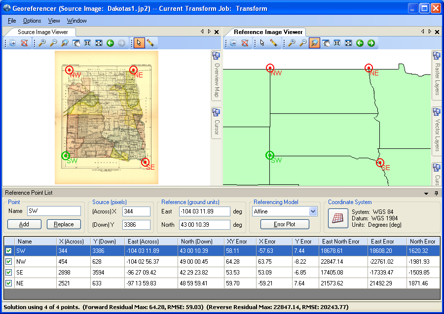
 Blue Marble Desktop created with the tools in GeoCore