GeoObjects? 4.1, the latest version from Blue Marble, now has expanded map display capabilities including support for S-57, EOO and other file types. This version also has improved zoom and pan features and vastly expanded sample code and documentation. Contact us directly for more information on our affordable license pricing.
Display TIGER/Line files directly!
GeoObjects? is the easiest and most affordable way to put maps in your application! This map display tool kit enables applications to present numerical data more effectively. GeoObjects? consists of a map OCX control and other OLE automation object controls for embedding spatial data access, display, conversion, and analysis capabilities into your Windows and Internet applications.
Embed smart, active, data-aware maps and CAD drawings into your Windows and Internet applications. Spatially enable your database!
A fully-enabled evaluation version is now available!
GeoObjects?
Features
New in Version 4.1
GeoObjects Map Display Features:
Enhanced support for E00 files
Added support for TIGER/Line files
Added support for S-57 files
Added Support for internally referenced images
Added Support for binary DXF files
Added the ability to manually specify datum shifts
Added support for the Hotine Two Point Projection
Added methods to control the zoom mode of the display window, making it easier to implement zoom-in, zoom-out, and pan features
Updated documentation with sample code
GeoObjects Vector File Conversion through the GeoConvert Control:
Added read support for BML files
Added read support for E00 files
Improved support for hatch-fills with DGN files
New in Version 4.0!
GeoObjects? 4.0 comes with support for Oracle Database connectivity. Specifically, Oracle support for Spatial Data Object (SDO) geometry types. We have introduced a new GeoConvert object - which will allow users to translate supported file formats: MIF, TAB, DWG, DXF, and SHP on-the-fly! Enhanced file format support includes AutoCAD 2004-2005, Microstation DGN, and MapInfo MIF file support. The overlay layer can now be written out as a TAB file and we have added display of the Blue Marble (BML) Layers similar to what we have in GeoView. There is also support for user-defined object types and datum shifts. Well Known Text (WKT) Coordinate System Definition support is introduced for the first time in GeoObjects? as well. Try it for yourself with a fully functional trial version of the software available for download from the Blue Marble website.
Features New as of Version 3.1!
GeoObjects? Version 3.1 comes with enhanced support for ECW, BSB, CADRG, and BIL file formats. Previous support for custom labels, Excel worksheets, and feature display and querying has been upgraded. New functionality has been added for drawing a grid on the map, and the map control now supports existing coordinate systems from .MAP and .PRJ files. This update is complete with new VB and DELPHI sample development code. Try it for yourself with a fully functional trial version of the software available for download from the Blue Marble website.
Display reprojected map files....on-the-fly!
Projects that are Perfect for GeoObjects?
Vehicle Tracking
Simple or complex map display or rendering
Custom map data display
Database display
Geographic or visual analysis tools
Other Features
Feature Level Rendition
Enhanced coordinate system and projection support
Overlay Layer
MrSID, ECW, TIFF and many other image formats are supported
Direct support for Microsoft Excel and dBaseIV point databases.
Geometry and Rendition Objects
Coordinate System Objects
Added functionality to existing Features and Layers
Feature level Renditions
GeoObjects? Map Control
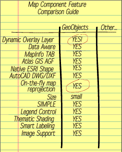
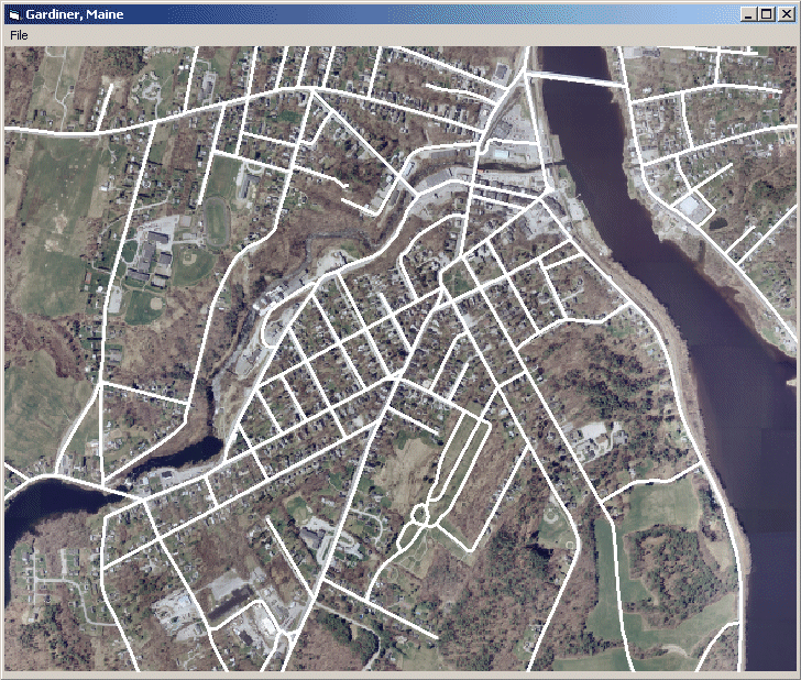
The map control displays maps, CAD drawings and images, provides map view manipulation controls (pan and zoom), supports spatial queries (click on a object and retrieve its feature name and attributes, etc), feature selection and highlighting, and automatically manages feature attributes from associated attribute databases. It is a data-aware "data bound" Visual Basic control. Simply connect the map control to a VB data control and you have spatially enabled your database!
Don't Be Locked into a single Map File Format!
Most map controls support only a single map format. Even worse, many only support a single proprietary map format. Refuse to be "locked in" to a proprietary map format! GeoObjects? even reprojects your map files "on-the-fly".
GeoObjects? map control directly displays (with absolutely no translation or coordinate system conversion necessary):
Native MapInfo Table (TAB and DAT/DBF)
Native MapInfo Interchange Format (MIF)
Native ESRI Shape (SHP and DBF)
Native ESRI Atlas GIS (AGF and AIF)
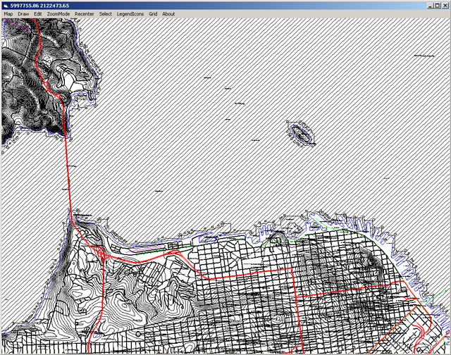
TIGER/Line
S-57
ArcInfo Export Format (E00)
Native AutoCAD (DWG) R2K, Version 2005 and earlier
Native AutoCAD (DXF) R2K, Version 2005 and earlier
Native MicroStation (DGN) Version 8.0 and earlier
Native Microsoft Excel (XLS)
Native dBase IV (DBF)
MrSID, ECW, TIFF, GeoTiff, PNG, and many other image formats
Robust image support!
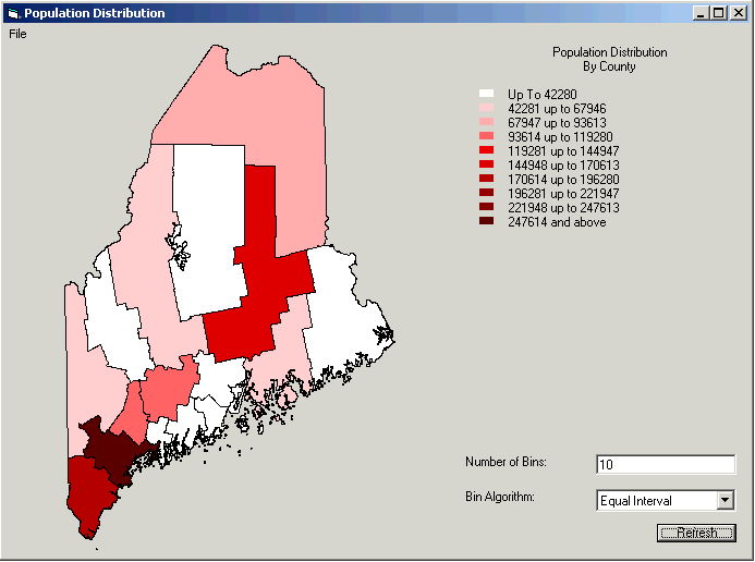
Thematic Shading
Thematically shade map features based on attributes contained within an associated user database. What does this mean? Connect a database of education statistics to a map of counties within your state. You can shade each county based on the number of pupils in each classroom. You can specify the color scheme and binning algorithm and GeoObjects? will automatically do the rest.
Thematic Shading
Data Bound
A map-to-user database connection can be made via Microsoft's Visual Basic data control, Microsoft's remote data control for data presentation. Simply connect the map control to a data control (DataSource). GeoObjects? automatically handles the database access details!
Royalty-free Map Data
10 MB of map data is included that you can distribute with your application.
Simple and Complete product diagram
GeoObjects?
Details
Map File Formats
Blue Marble Layer (BML)
S-57
TIGER/Line
Native MapInfo Table (TAB and DAT/DBF)
Native MapInfo Interchange Format (MIF)
Native ESRI Shape (SHP and DBF)
Native ESRI Atlas GIS (AGF and AIF)
Native AutoCAD (DWG) 2004-2005 and earlier
Native AutoCAD (DXF) 2004-2005 and earlier
Native MicroStation (DGN) Version 8.0 and earlier
ArcInfo Export Format (E00)
Point File Formats
Native Microsoft Excel (XLS)
Native dBase IV (DBF)
Image File Formats
LizardTech MrSID
Enhanced Compressed Wavelet (ECW)
TIFF (TIF)
jpeg (jpg)
CADRG/ADRG
PNG
BSB/KAP
PCX
TGA
BIL / HDR
BMP
GeoTiff
JP2
Data Access
Oracle Spatial Data Objects (SDO)
Microsoft's Visual Basic data control
Microsoft's remote data control
OLE Control 96 Specifications Honored
Drawing optimization
Flicker-free activation / deactivation
Flicker-free drawing
Legend Control can be a windowless control
Quick Activation
Textual persistence of controls.
Map Control Properties
AutoDrag
AutoDraw
AutoPick
BackColor
BinAlgorithm
BinCount
Bins
Center
ColorAlgorithm
CoordinateSystem
CurDataX, CurDataY
DataField
DataField Type
DataSource
EnableContextMenu
Images
KeepAspect
Layers
MapGrid
MapProperties
NameField
PickAperature
PickedFeatures
PickFilter
RegionOfInterest
RestrictedView
ReverseColorOrder
RotationAngle
SaveInvisibleObjects
ScaleFactor
ScaleLimit
SpatialDataName
SpatialDataType
TotalDataExtent
ZoomAmount
ZoomMode
Map Control Objects
ArcGeometry
Bin Object
Bins Collection
BMGeoMap
CoordinateSystem
CustomGeometry
Datum
EllipseGeometry
Ellipsoid
Feature Object
Feature2 Object
Features Collection
GoBrushRendition
GoFontRendition
GoPenRendition
Image Object
Image2 Object
Images Collection
Layer Object
Layer2 Object
Layer3 Object
Layers Collection
LayerProperties
LegendIcon
LineGeometry
MapGrid
MapProjection
MapProperties
OleMinMax
OlePoint
OleRectangle
OverlayLayer
PickedFeatures Collection
PointGeometry
PolygonGeometry
RectangleGeometry
SymbolGeometry
TextGeometry
Map Control Methods
AboutBox
AddLayer
ClearMap
ConvertCoordinate
ConvertDistance
Copy
DeleteImage
DeleteLayer
DoPick
DoPickByArea
DoPickByRadius
DoPickByRectangle
DrawBMP
FlushUserData
GetMapScale
GetOverlayLayer
GetViewScaleRange
Paste
PrintView
Refresh
ReloadUserData
ResetMap
SaveOverlayLayer
SetAttributeCallback
SetCenterXY
SetCustomDrawCallback
SetMapScale
SetViewScaleRange
Map Control Events
Change
Click
DblClick
KeyDown
KeyPress
KeyUp
LoadFinished
LoadStarted
MouseDown
MouseLeave
MouseUp
MouseMove
Map Projections
Albers Equal-Area Conic
Azimuthal Equidistant
Behrman
Bonne
CassiniSoldner
Cylindrical Equal-Area
Cylindrical Equidistant
Eckert1 Pseudocylindrical Equal-Area
Eckert2 Pseudocylindrical Equal-Area
Eckert3 Pseudocylindrical Equal-Area
Eckert4 Pseudocylindrical Equal-Area
Eckert5 Pseudocylindrical Equal-Area
Eckert6 Pseudocylindrical Equal-Area
Equidistant Conic
Finland KKJ Two Point Fit
Gall Cylindrical
Gnomic
Hammer Aitoff
Hotine Two Point
Hotline Oblique Mercator
Lambert Azimuthal Equal-Area
Lambert Conformal Conic
Latitude / Longitude
Mercator Conformal Cylinder
Miller Cylindrical
Mollweide Pseudocylindrical Equal-Area
New Zealand Map Grid
Orthographic
Peters
Plate Carree
Polyconic
Quartic Anthalic
Robinson Pseudocylindrical
Sinusoidal Pseudocylindrical Equal-Area
Stereographic Azimuthal Conformal
Transverse Mercator
Van Der Grinfen I
Winkel 1, 2
GeoObjects?
Who's Using GeoObjects?
We have over 120,000 customers around the world, here are just a few:
Nasa
Ericcson
Lucent
The FAA
The National Park Service
Chevron - Texaco
Boeing
Shell
Exxon-Mobil
Thales Geosolutions
Lockheed Martin
Oracle
British Geological Survey
BP Amoco
Harvard University
Yale School of Architecture
Yale University
Princeton University
Domino's Pizza
User Comments
"The speed and ease of use that is engineered into GeoObjects? is no mistake. As an example of how fast and easy it can be, my son had my GeoObjects? multi-format viewer built the first time in less that two hours. Last night, he did it again on my laptop in about half an hour. GeoObjects? also works on the Web. In less than three hours my son had it working for a show-and-tell example at Intergraph. It read four file formats, created thematic maps, and showed attributes from selected features. Most of that three hours was spent loading Internet Explorer 5.0, not creating the application."
Hal Reid -Directions Magazine
"Small, fast, and feature rich, we have yet to find a better solution for displaying multiple data formats in a single package."
R. Martinson - Web Architect, LimeLyte
"GeoObjects? is simple and complete, our environmental database visualization app was built in a single day! Most importantly, we didn't have to translate our map files, we hooked them up directly without conversion. This alone saved us the cost of the product many times over! Blue Marble and their products are world-class!"
M. McMaster - President, Four Towns Watershed Association.
Q: What vector map file formats does GeoObjects? support? A: GeoObjects? supports ESRI Shape (SHP), Atlas GIS (AGF), Blue Marble Layer (BML), Microstation (DGN Version 8.0 and earlier), AutoCAD (DWG and DXF, AutoCAD 2005 and earlier), ArcInfo Export (E00), MapInfo Interchange (MIF), S-57, MapInfo Table (TAB), and TIGER/Line format files directly without conversion.
Q: What are the advantages of the native MapInfo TAB format over the MapInfo Interchange Format (MIF)? A: There are many. TAB files can be managed much more quickly and efficiently since MIF files are ASCII files and TAB files are stored in a binary format. MIF files are created by translation from another format or by exporting native data from MapInfo. They will never represent map data as correctly or completely as native TAB files will. Information is most usually lost in the translation or export process. The differences between TAB and MIF are as significant as the differences between native AutoCAD DWG and AutoCAD DXF files. As well, there are many maps published directly in the TAB format. You will be able to handle these maps directly, without conversion to MIF with the subsequent loss of information in the translation process.
Q: What raster image file formats does GeoObjects? support? A: GeoObjects? supports ARC Digitized Raster Graphics (ADRG/CADRG), GeoSPOT (BIL/HDR), Windows Bitmap (BMP), NOAA Nautical Chart (BSB/KAP), Enhanced Compressed Wavelet (ECW), GeoTIFF, JPEG, JPEG 2000 (JP2), LizardTech MrSID, Portable Network Graphics (PNG), TrueVision XFile (TGA), and Tagged Image File Format (TIF).


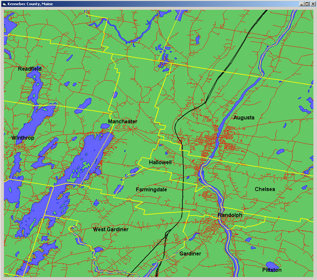
 Display TIGER/Line files directly!