|
모델
생성하기
프로젝트 마법사(Project Wizard)
향상된 프로젝트 생성 마법사가 여러분의 프로젝트
목적에 맞는 최적의 수치 엔진을 선택하도록 도와 줄
것입니다. 또한, MODFLOW-2000, MODFLOW-96 그리고
MODFLOW-88 데이터들을 읽을 수 있습니다.
Site Map Layers
현장 지도를 읽어서 여러분의 모델에 중첩할 수
있습니다. 지원되는 파일 형식 예 - AutoCAD(.DXF),
Shapefiles(.SHP), 래스터 이미지들(.BMP, .JPG, .GIF)
|
Calculated
heads using MODFLOW
|
|
Grid Design
Visual MODFLOW는 모델 격자를 현장 특성과 지하수
흐름 방향과 일치시키기 위해 현장 지도(.DXF 또는
.BMP)에 대해 모멜 도메인(Domain)를 회전시킬 수 있습니다.
유한 차분 격자를 추가, 삭제, 이동 등 편집할 수 있고
행, 열 그리고 레이어들을 자동으로 정제(refine)해줍니다.
Automatic Grid Smothing
적합한 격자 간격의 모델 격자를 설계하여 사용자가
필요로 하는 상세 정도를 제공하면서 솔루션에 요구되는
면적에 대한 수치적 안정성을 유지하는 것이 중요합니다.
|
Assigned
hydrogeological properties to each grid cell
|
|
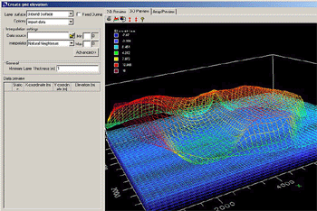
Importing Layer Elevations
대부분의 대수층(aquifers)은 '평평한' 레이어가
아니므로, Visual Studio는 surface 데이터를 ASCII(X,
Y, Z), Surfer(GRD), USGS DEM(.DEM), ESRI(.GRD),
MapInfo(.GRD) 파일로부터 불러 올 수 있습니다.
XYZ ASCII 파일들들(TXT), MS Access Database (MDB),
MS Excel (XLS), 그리고 ESRI Point Shape files (SHP)로부터
레이어 표고 데이터를 불러와서 내삽처리할 수 있습니다.
제어점들을 지정, 내삽 결과를 다룰 수 있는 옵션을
제공합니다.
|
Import
and interpolate layer elevations and property zones
|
|
Grid Cell Elevation Editor
이 툴은 Array editor를 이용하여
각 셀의 개별 표고(elevation)을 편집할 수 있게 해줍니다.
드래그 앤 드롭(Drag-and drop) 방식을 이용하여 횡단면에서
셀 표고들을 편집할 수 있는데, 셀 두깨를 늘이거나
압축할 수 있습니다.
|
|
|
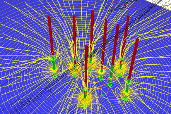
우물 양수(Pumping Wells)
직관적인 우물 편집기(well edit
tool)을 이용하여 우물 양수 또는 주입을 추가하거나
복사 또는 제거할 수 있고, well screen 간격을 그래픽저으로
윤곽을 그리거나 ASCII 텍스트 파일로부터 실시간 양수
스케쥴을 불러 올 수 있습니다. 우물 양수가 많은 사이트의
경우, Visual MODFLOW는 양수 관련 모든 데이터들을
불러 올 수 있습니다.
.txt, .vc, .shp, .xls, .mdb
파일들로부터 불러 올 수 있습니다.
Multiple well screens for a single well are easily
accommodated while the pumping rate distribution
between layers is automatically calculated based
on the transmissivity of the layers through which
it is screened.
|
|
|
Observation Wells
Visual MODFLOW Pro is the only MODFLOW modeling
environment that allows you to assign multi-level
observation wells, just like ones you have in the
field. In addition, Visual MODFLOW is the only modeling
software package that allows you to group the observation
points into one or more observation groups. This
grouping feature is used for interpreting the calibration
data for an isolated section(s) of your model domain.
Properties
Visual MODFLOW Pro separates the model properties
into two distinct categories:
|
|
|
Flow Properties
Those physical model
properties affecting the groundwater flow simulation.
Flow properties include; hydraulic conductivity
(Kx, Ky, and Kz), specific storage (Ss), specific
yield (Sy), porosity and initial heads.
Transport Properties
Those physical and chemical
model properties affecting the fate, migration and
degradation of a contaminant plume in groundwater,
or adsorbed to the soil. Transport properties include;
dispersion (Dx, Dy and Dz), bulk density, distribution
coefficient (Kd), decay constants, initial concentrations.
|
|
|
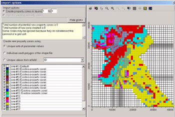
Import property zones from ESR1 polygon (.SHP)
files.
Properties can be interpolated from XYZ ASCII
files (TXT), MS Access Database (MDB), MS Excel
(XLS), and ESRI Point Shape files (SHP). Interpolation
options include Natural Neighbor, Kriging, and Inverse
Distance.
|
|
Boundary Conditions
MODFLOW boundary conditions supported by Visual
MODFLOW Pro include both steady-state and transient
Constant Heads, Rivers, General Heads, Drains, Recharge
and Evapotranspiration. The Horizontal Flow Barrier
package is also supported.
Visual MODFLOW Pro also supports all contaminant
transport boundary conditions available for the
latest versions of MT3D including MT3DMS for multi-species
transport, and RT3D for reactive transport and natural
attenuation simulation. These include constant,
recharge, or evapotranspiration concentration, and
point source.
For transient simulations, real-time schedules
of boundary condition values can be entered directly
or imported into the time schedule from an ASCII
text file. Recharge and evapotranspiration boundary
conditions can be imported from ESRI polygon shapefiles.
Particles
Forward or backward tracking particles can be
easily assigned for determining advective transport,
preferred flow pathways and delineating well capture
zones. Visual MODFLOW Pro’s intuitive graphical
tools allow you to easily assign single particles,
lines of particles and a circle of particles anywhere
in your model domain.
Zone Budget
The Zone Budget package allows you to produce
zone-to-zone flow summaries for regions of interest
in your model domain. Define zone budget flow observations,
such as baseflow to a stream, or flux across a boundary,
which can be used for calibrating the groundwater
flow model against data other than just head measurements.
Zone budget observations can be included in WinPEST.
Enviro-Base Pro
Visual MODFLOW Pro now integrates Enviro-Base
Pro - an all-in-one database designed to house a
variety of referenced property information used
when developing groundwater models. Enviro-Base
Pro enables you to consolidate your technical references
into one package that can be easily launched, searched
and updated.
|
|
시뮬레이션
실행하기
설정 실행하기
Visual MODFLOW를 이용하여, 여러 모델들을 연속해서
실행하기 위한 배치 파일을 쉽게 설정할 수 있습니다.
이러한 강력한 기능을 이용하여 동일 모델에 대해 여러
버전을 만들어 실행하면서 다른 작업을 할 수 있습니다.
●
Initial head estimates (import from ASCII or Surfer,
or previous run). Option to calculate VCONT from
ground elevation or initial heads
●
Number of time-steps and time-step multiplier
●
Solver selection and convergence settings
●
Recharge layer settings
●
Layer-types (e.g. confined, unconfined)
●
Rewetting options, including option to maintain
a minimum saturated thickness for dry cells and
to specify a head value in these cells equivalent
to the cell bottom elevation.
●
Anisotropy option
MT3D
run settings include:
●
Initial concentrations (import from ASCII or Surfer)
●
Solver and advection package settings (UFD, TVD,
MOC, MMOC, HMOC)
●
Simulation output times
Advanced Settings
For the advanced users of MODFLOW, you can substitute
your own manually created input data files for any
MODFLOW by using the Advanced Settings. The Advanced
Settings allows you to specify which files you will
use from Visual MODFLOW Pro, and which files you
will substitute.
Batch Runs
Visual MODFLOW Pro also now allows you to easily
set up a batch file to run several models in succession.
This is a very powerful feature that allows you
to create several versions of the same model and
then run the models while you are doing other tasks.
The Win32 MODFLOW Suite
Visual MODFLOW Pro includes the Win32 MODFLOW
Suite with MODFLOW-2000, MODPATH, Zone Budget, MT3DMS
and RT3D compiled to run as true Windows, 32-Bit
applications. This unique and powerful modeling
utility actually provides you with the ability to
control the numerical solution process by manipulating
the solver parameters and convergence criteria while
the solution is in progress. In addition, it provides
a real-time graphical display of the solution convergence
data and a detailed graphical summary of the Zone
Budget results.
After each successful run has completed, the
Win32 MODFLOW Suite automatically produces all of
the necessary files required for you to analyze
and interpret the results, and produce full-color,
report-quality graphical presentations using Visual
MODFLOW Pro’s post-processing graphical features.
|
|
Power
Features
USGS SEAWAT v.4
SEAWAT is a generic MODFLOW/MT3DMS-based computer
program designed to simulate three-dimensional variable-density
groundwater flow coupled with multi-species solute
and heat transport. The program has been used for
a wide variety of groundwater studies including
those focused on brine migration in continental
aquifers as well as those focused on saltwater intrusion
in coastal aquifers. SEAWAT uses the familiar structure
of MODFLOW and MT3DMS. Thus, most of the commonly
used pre and post-processors can be used to create
SEAWAT datasets and visualize results.
SEAWAT Version 4 is backward compatible with
datasets created for SEAWAT-2000 and, therefore,
SEAWAT-2000 is no longer supported or maintained.
MGO - Modular Groundwater Optimizer
Modular Groundwater Optimizer is a simulation
optimization software system, that can be used to
reduce the costs associated with installing and
operating a pump-and-treat remediation system. MGO
code can be applied with no or minor modification
to a variety of groundwater resource management
issues and other types of remediation systems such
as bioremediation, optimization of groundwater pump-and-treat
systems.
GMG Solver Implementation
The new Geometric Multigrid Solver (GMG) solver
from USGS has been integrated with the MODFLOW-2000
and SEAWAT-2000 Engines. GMG is based on the geometric
multigrid solver method. The GMG solver has been
demonstrated to greatly reduce model run times relative
to other solvers using a comparable amount of memory.
MNW - Multi-Node Well
The simulation of pumpage by wells is a fundamental
and widely used feature of ground-water models such
as MODFLOW. Visual MODFLOW’s new addition, the
Multi-Node Well Package, is designed to help simulate
wells with well screens that span multiple layers.
Now you can accurately simulate pumping wells screened
in multiple aquifers.
|
|
Add-on
Packages
MIKE 11
MIKE 11, developed by DHI, is a world-recognized
surface water modeling package designed for simulating
the hydrodynamic conditions found in rivers, lakes,
reservoirs, and irrigation canals. Visual MODFLOW
Pro and MIKE 11 are now available as a fully coupled,
groundwater and surface water simulation environment.
This impressive combination represents the only
truly conjunctive groundwater/surface water model
combining USGS MODFLOW 2000and DHI’s MIKE 11. Ideally
suited for:
●
Analyzing the hydraulic connection between rivers,
streams, and aquifer systems
●
Determining groundwater base-flow and potential
impacts to ecologically sensitive areas
●
Calculating infiltration rates from surface water
to groundwater during rainfall events
●
Developing comprehensive watershed management plans
MODFLOW-SURFACT
MODFLOW-SURFACT is a three-dimensional finite-difference
flow and transport program containing many advancements
and improvements over the standard public-domain
versions of MODFLOW.
With more robust solution methods and enhanced
simulation capabilities for handling complex saturated/unsaturated
subsurface flow and transport processes, MODFLOW-SURFACT
is specifically designed to address the many limitations
and short-comings of the standard MODFLOW codes.
Use MODFLOW-SURFACT when simulating:
●
Multiple water tables, or perched water table systems
●
Steep water table gradients crossing multiple model
layers
●
Over-pumped wells screened across multiple model
layers
●
Surface water infiltration through the vadose zone
to the water table
●
Large water table fluctuations causing desaturation/
resaturation of grid cells
●
Soil vapor flow through the unsaturated zone
|
|
결과
해석 및 표출
In order to get the most out of the model that
you build, it is critical that you have the tools
necessary to properly analyze the results.
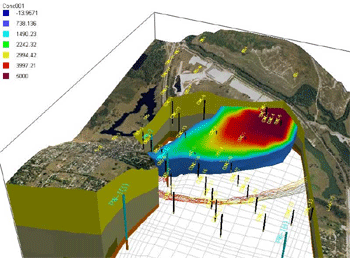
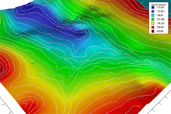
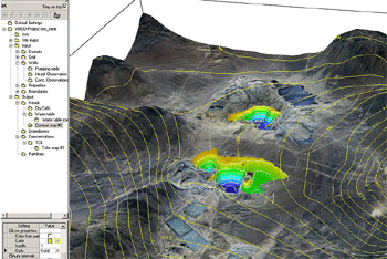
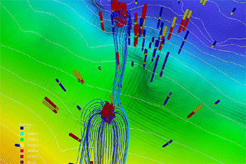
Contouring and Color Maps
●
Visual MODFLOW Pro creates detailed contour maps
of modeling results including:
●
Heads, drawdown and multi-species concentrations
●
Water table elevations/depth and net recharge
●
Head difference between layers and flux between
layers
High-quality color shaded contouring is also
available for creating presentation quality color
maps of all contoured results.
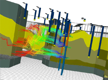
Flow Velocity Vectors and Pathlines
Visual MODFLOW Pro displays flow velocity vectors
and flow pathlines. Flow velocity vectors can be
used to effectively illustrate the direction and
magnitude of groundwater flow velocity throughout
the model domain.
Export Options
Export model display to Raster image format (.BMP,
.JPG, .TIF, .PNG, .TIF), or AutoCAD (.DXF) in model
or world co-ordinates
Export contour lines, velocity vector maps, and
pathline locations to ESRI Shapefile (.SHP) in model
or world co-ordinates
Export a wide variety of gridded data to ASCII
.TXT, Surfer .GRD, or TecPlot (.DAT) Visualization
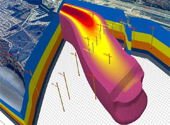
using VMOD 3D-Explorer
To achieve an in-depth understanding of your
model, and to effectively present the model results
to clients or the general public, we’ve incorporated
powerful two and three dimensional visualization
and animation tools through the VMOD 3D-Explorer.
●
Create contour/color maps of model properties and
simulation results
●
Present graphical summaries of global and local
mass budgets
●
Create model calibration plots and statistical summaries
including mean error, absolute mean error, standard
deviation, and many more!
●
Full control of map overlays - save your overlay
configurations and view only the overlays you require!
●
Display 3D pumping wells and observation wells
●
Represent soil property zones and boundary conditions
in 3D
●
Render high resolution 3D volumetric contaminant
plumes
●
Create irregular shaped cross-sections
●
3D pathlines with time markers
●
Define 3D cut-away regions
●
Animate sequential degradation of contaminant plumes
and save into AVI file format for use in Microsoft
PowerPoint presentations!
Mass Budgets for Flow and Transport
Visual MODFLOW Pro produces detailed tabular
and graphical reports of the mass balances for both
the flow and mass transport simulations. These reports
provide global and local summaries of the mass inflows
and outflow from the system, or from a localized
region of the model.
Printing
Visual MODFLOW Pro prints full-color, high-resolution
graphics to any printer or plotter supported by
Windows. The graphical display of the simulation
results and/or input files can be printed in portrait
or landscape format as a full-page image or with
a title block that describes the details of the
model and the results being displayed. Color-shaded
contours can be printed with or without a color
legend.
Visual MODFLOW Pro also prints the on-screen
display to several graphics file formats and exports
results to ASCII files in two or three dimensional
format.
|
|
모델
보정
WinPEST
WinPEST has been seamlessly integrated into Visual
MODFLOW Pro to allow you to conveniently select
the model parameters you want to optimize, and then
easily launch the built-in WinPEST application directly.
WinPEST not only modifies the MODFLOW input data
files, it also modifies and updates the Visual MODFLOW
Project data files. This makes it much more practical
and convenient to re-load your model files once
the automated calibration procedure is completed.
Supported parameters for a PEST simulation include
flow properties and recharge. You can include head
and/or concentration observations, and zone budget
observations in the objective function.
During PEST execution, you can view a number
of useful pieces of information for displaying and
interpreting the PEST simulation results, many of
them in real-time graphical form. You can also see
how PEST adjusted the values of the parameters during
the optimization process.
In all of these plots, Right-Clicking on the
graphs and selecting Properties will allow you to
alter the appearance of the plots. These plots include:
| Objective Function (Phi) |
Covariance |
| Composite Sensitivity |
Eigenvectors and Eigenvalues |
| Parameters History |
Uncertainties |
| Marquardt Lambda |
Residuals |
| Calculated vs. Observed |
Residual Histogram |
| Jacobian |
Prediction |
| Correlation |
Regularization Weight
Factor |
Tools for Manual Calibration
An extensive set of built-in model calibration
plotting utilities and statistical calculations
help you properly evaluate the modeling results
and interpret the calibration data. Comprehensive
calibration plotting utilities and statistical summaries
provide you with all the graphical interpretation
tools you need to properly and thoroughly analyze
the model calibration data.
Visual MODFLOW allows you to assign multi-level
observation wells and group the observation points
for isolated analysis of local model regions.
For each simulation Visual MODFLOW calculates
the following calibration statistics:
●
Mean Error
●
Mean Absolute Error
●
Standard Error of the Estimate
●
Root Mean Error
●
Normalized Root Mean Error
These statistics can be calculated for all observations,
or just for selected groups of observation points
(as defined by the user).
The calibration plotting options provided include:
●
Scatter plot of calculated vs. observed data
●
Histogram of calibration residuals
●
Time-series plot of calculated and observed data
●
Time-series plot of calibration statistics
●
Bubble plot of calibration residuals
All plots can be exported to common image format
(.BMP, .JPG, .TIF, .PNG), and the plot data can
be exported to .ASCII for further analysis.
|
|
시스템
요구 조건
●
Supported on Windows XP Pro SP2, and Windows Vista
(Business, Enterprise and Ultimate)
●
RAM: 512MB and 1GB (or more) would be recommended
●
Hard drive space: 200MB
●
A minimum screen resolution of 1024 X 768
●
A Microsoft compatible mouse
●
Microsoft Framework 2.0 installed
|
|
|
|
Visual
MODFLOW 버전별 기능 비교
|
|
|
|