
필요한 최적의 소프트웨어와 컨설팅을
공급하도록 노력하겠습니다.


Blue Marble Desktop? |
 | ||||||||||
| For Raster, Vector, Coordinate, CAD, LiDAR and DEM Geospatial Data | |||||||||||
The Blue Marble Desktop is the all in one geospatial data management platform for Blue Marble?s popular data transformation tools. The Geographic Calculator and Geographic Transformer reside in the same desktop window along with a Spatial Connect module for working directly with spatial databases. Access all of these available features in a single interface through a combined license. Whether you are working with coordinate, vector, CAD, raster, 3D, LiDAR, DEMs, DTEDs or any type of geospatial data the Blue Marble Desktop allows you to address your data conversion challenges in the same application interface. Users can now translate directly between twenty different vector and CAD file formats and some sixty different spatial formats. The Spatial Connect module allows Blue Marble Desktop to connect to Esri geodatabases, Oracle and PostGIS. The ArcGIS Extension now features support for Esri Spatial database conversions for SDE, File Geodatabase, and Personal Geodatabase. The Blue Marble Desktop enables users to edit and share the same geodetic datasource (GeoCalc.xml) across your organization regardless of location. It also features a Project Manager that allows administrators and managers to create, save and share data conversion projects which can be made available to many users. Managers can also pre-configure the geodetic datasource, ensuring high quality data conversion and minimize costly mistakes.
Version 2.4 contains several new and enhanced features, which gives users more control over more of their data. A new Seismic Survey Conversion job lets you access, maintain, and convert SEG, SPS and UKOOA formatted ASCII data faster and more efficiently. There is a new Web Mapping Service (WMS) interface for remote data connections in all data viewer windows. Well Known Text and PRJ coordinate system matching now preserves base geodetic coordinate system references. Enhanced Envelope logic preserves systems that cross the International Dateline. An updated Audit Trail now tracks the current Desktop user with all changes. |
|||||||||||


Blue Marble Desktop? |
| |
| For Raster, Vector, Coordinate, CAD, LiDAR and DEM Geospatial Data | ||
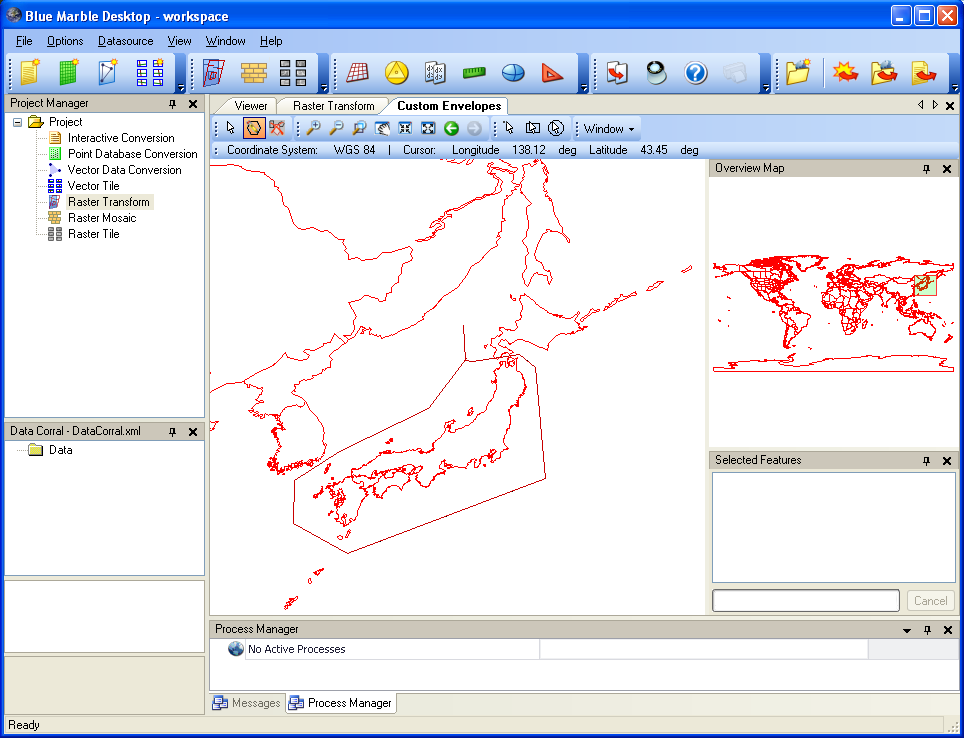
FeaturesGeospatial Conversion, Translation and Transformation in One ApplicationGeographic Calculator and Geographic Transformer now reside in the same desktop window. Work seamlessly with all of the features of both applications in a single interface through a combined license.Work off of the same GeoCalc datasource, set custom views and editing capabilities, define jobs with workspace files, and set up powerful batch projects across geodetic, vector and raster data. The Blue Marble desktop will save your organization time, reduce errors and increase reliability of all your geospatial data. Features
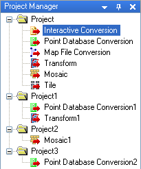
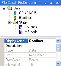
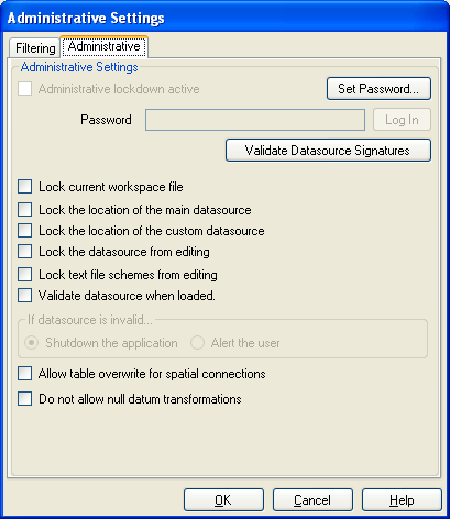
Metadata EditorThis tool comes with read and write support for XML and text-based metadata files which are compliant with both FGDC and Esri. Data files from many sources include accompanying metadata files in either the .xml or .txt format. The Point Database Conversion, Vector Data Conversion, Vector Tile, Raster Transform, Raster Mosaic, and Raster Tile jobs of Blue Marble Desktop all include a Metadata button for accessing existing metadata which can then be edited and saved. Project ManagerThe Project Manager panel introduces the concept of workspaces, projects and jobs. Switch back and forth between multiple conversion projects. Save off a workspace and send it to other users to use your settings or have all users save settings to a central server for easy sharing. Name workspaces, projects and jobs based on the specific type of work or conversion. Use our docking capabilities to further customize the view. For example you can open the map viewer, drag it to the bottom of the interface and set it below all the transformation windows. You can also minimize or close windows all together. All of these settings can then be saved in a workspace. File CorralThe file corral allows users to manage data locally or remotely. Use this tool to further enable workspace guidance for co-workers. Save off the path to all the essential map data (vector and raster) to the project. When you share that workspace or open it again it will remember where your data is residing. Administrative ToolsLock down the data source for protection through password access limiting who can edit geodetic definitions and views on the datasource. The GIS Manager or Geodesist in your organization can show the coordinate objects they prefer by limiting views on the datasource through password access. For example if you don?t want your users to see all twenty plus linear units, only meters, you can set up a custom view that shows just meters and save that view off under a certain password. Or maybe you?re only working in one part of the world, Canada for instance, customize the coordinate datasource to only show coordinate objects appropriate for Canada. Then use the workspaces protocol to send that set up our to your users. Workspaces ensure consistency and permit developing pre-defined jobs and making them available to co-workers as well. You can set a number of different preferences for geodetic and data transformation from the number of decimal degrees to the default datum to the file path, save it off in a workspace under a job and project of a specific name, then make that available to your co-workers and users. Another great administrative tool is our datum shift envelope capability, recently expanded to include coordinate systems and horizontal datums. You can define geographic envelopes view the admin tools, or use our predefined envelopes and select the appropriate datum shift for that area of the world. Your users will automatically be prompted to use that shift when they are transforming data in that part of the world. Desktop also allows you to use this same envelope functionality over the ArcMap interface through the Geographic Calculator Esri extension! | ||
 The Blue Marble Desktop
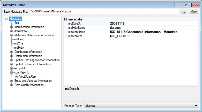
Blue Marble Desktop? |
| |
| For Raster, Vector, Coordinate, CAD, LiDAR and DEM Geospatial Data | ||
DetailsSupported Input Image File Formats
Supported Output Image File Formats
Image Reference Formats
Supported Input Digital Elevation Model Formats
Supported Output Digital Elevation Model Formats
Point Database Formats
Supported Input Vector File Formats
Supported Output Vector File Formats
Spatial DatabasesThe Spatial Connect Module supports:
Image Transformation Models
Datum Transformation Methods
Coordinate Conversion ParametersWe include a comprehensive coordinate conversion parameter database that contains most common coordinate systems in use throughout the world. You can completely customize this XML file by adding or removing parameters. Currently, the coordinate conversion database contains:
Common coordinate systems included:
Alberta Township System (ATS) Grid Versions
Map Projections
Vertical DatumsAdditional download may be required
| ||

