
연구의 선진화와 생산성 향상에
필요한 최적의 소프트웨어와 컨설팅을
공급하도록 노력하겠습니다.
필요한 최적의 소프트웨어와 컨설팅을
공급하도록 노력하겠습니다.


What's New in Strater 4
Strater 4 takes well log, borehole and cross section plotting to a new level in ease of use. Strater users will experience major improvements in every aspect of functionality to increase log production speed and quality. The major additions and changes are highlighted in this section.

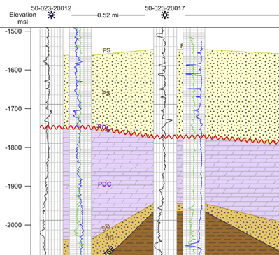
Display deviated boreholes as inclined logs in the cross section view
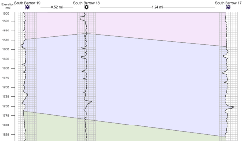
 Display the logs in the cross section as inclined according to their deviation data!
Display your borehole inclination or dip in the cross section.
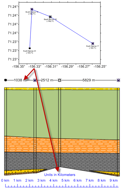
Show deviation paths of wells in the map view
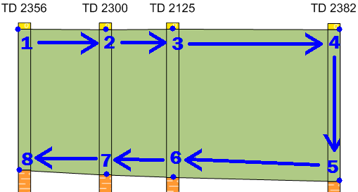
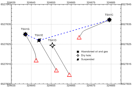 In most industries vertical boreholes are the stuff of legends. Strater 4 recognizes this and allows you to show the true path of your borehole in the map view.
Show the true deviation path of your boreholes on the map view.
Set and change coordinate system in the map view
It’s never been easier to add combine data from a multitude of sources to create the most informative maps possible.
Now that Strater supports Golden Software’s full coordinate system library, you can mix and match data from different coordinate systems, giving you tremendous flexibility and times savings when creating your maps and displaying cross sections in the desired units!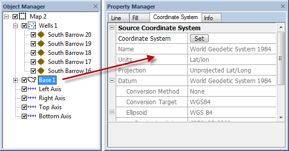
Set the coordinate system of each of your map layers and change the coordinate system of the map as a whole in this easy-to-use setup.
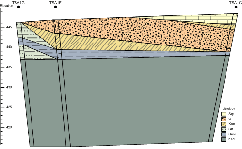
Create cross sections from line logs
 Don’t have lithology data for your boreholes? Not to worry! Strater 4 allows you to create a cross section from line logs. Add or import layer marks to indicate the layer picks, and then specify if they are the tops or bottoms of the layer.
Create a visually stunning cross section from geophysical or other depth-registered data.
Create cross section layers manually
 If you’re not happy with the default cross section layers that Strater creates for you, delete them and easily and quickly create your own layers! Customize your cross sections using your years of experience to guide you.
With a few simple clicks you can create manual cross section layers that reflect what you know to be true about the subsurface.
Export data to Voxler using new commands
 Compatibility with Voxler is now even better! Utilize the stunning 3D visualization of Voxler to show your well paths and volumes.
Export from your Strater tables to display VolRenders and WellRenders in Voxler’s 3D interface.
Show the header and footer only on specified pages
Pick your pages: only show the header or footer on the first page, last page, or on all pages in the view or when you print.
Pick your pages: only show the header or footer on the first page, last page, or on all pages in the view or when you print.
Choose to show the header only on the first page and the footer only on the last page!
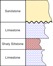
Draw unconformity lines to show an unconformable contact
Draw an unconformity between different lithologies in any view! You have complete control over the amplitude and wavelength of the waves.
Draw an unconformity between different lithologies in any view! You have complete control over the amplitude and wavelength of the waves.
Draw unconformable contacts between lithologies in your borehole (left) or cross section (right) view.
Add a horizontal scale bar to a cross section
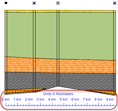
Add horizontal scale bars to your cross section, and change the display units!
Add horizontal scale bars to your cross section, and change the display units!
Display the distance across your cross section using a horizontal scale bar.
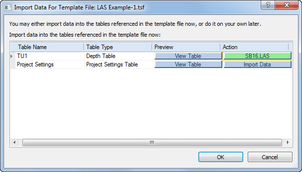
Templates are easier to use!
Open a template and import the data for all tables immediately! When you click OK, the log is exactly what you need without spending extra time importing data into all the individual data tables.
Open a template and import the data for all tables immediately! When you click OK, the log is exactly what you need without spending extra time importing data into all the individual data tables.
Import data to use in the template as soon as you open the template file! Once you import data for a table in the template this is indicated by a change of color.
Change the units in the cross section well header or the scale bar!
You have full control over the units displayed in the well header and scale bar in the cross section view. As long as the map has units defined, you can convert the units (even lat/long!) to any other units such as meters, feet, miles or kilometers to display on the cross section.
You have full control over the units displayed in the well header and scale bar in the cross section view. As long as the map has units defined, you can convert the units (even lat/long!) to any other units such as meters, feet, miles or kilometers to display on the cross section.
Change the units of the well header and scale bar in the cross section. For example, a map in latitude and longitude can display well headers in meters and a scale bar in kilometers.
Set the Spacing of Multiple Objects
Do you want all your logs exactly next to each other? The space objects commands now work on more than 2 objects at a time!
Do you want all your logs exactly next to each other? The space objects commands now work on more than 2 objects at a time!
Select your logs, click the button and all the space is removed between the logs.
Set the Spacing Between Objects
Set all your logs exactly the same width apart! No more painstaking math to calculate the position of each log, or inaccurate eyeball spacing!
Set all your logs exactly the same width apart! No more painstaking math to calculate the position of each log, or inaccurate eyeball spacing!
Set the spacing between multiple selected objects, such as the spacing between all logs in your view, with one simple command.
Wrap Linked Text to Multiple Lines
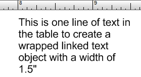
Specify the width of a linked text object, and any text that exceeds that length is wrapped to the next line!
Specify the width of a linked text object, and any text that exceeds that length is wrapped to the next line!
Specify the width of your linked text object and have the text wrap to multiple lines.
Replicate Your Borehole View
Creating an exact copy of a borehole view in your project is easy with the new view-only template! Previously, you could only save as a full template, complete with data tables and all views in the project. If you only wanted one view, you would need to delete all the extra information after the template was loaded.
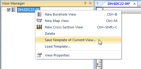 Now you can save only a single borehole view as a view-only template; no data tables, no extra views. Just save the view to the view template, open the view template, assign the existing data (or choose to import new data), and the copy is created!
Creating an exact copy of a borehole view in your project is easy with the new view-only template! Previously, you could only save as a full template, complete with data tables and all views in the project. If you only wanted one view, you would need to delete all the extra information after the template was loaded.
Save a single borehole view to a view-only template file! No data tables, no extra views; just the information you need.
Specify Inclination or Dip for Hole Angle
Specify the angle of the hole as either inclination or dip! Previously, you could only use inclination. Don’t modify your data to work with Strater, choose to let Strater handle your data as it is!
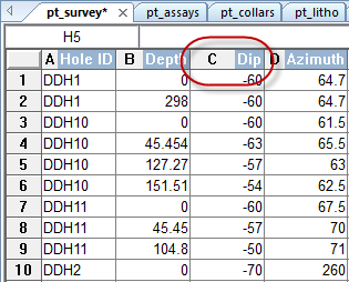
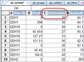
Specify the angle of the hole as either inclination or dip! Previously, you could only use inclination. Don’t modify your data to work with Strater, choose to let Strater handle your data as it is!
Import your survey data specifying the hole angle as either dip or inclination data! It is your choice.
Additional Usability Enhancements
- Set the Reference Datum in the borehole view to hang the view on mean sea level or a marker bed.
- Format numeric text labels in complex text logs, zone bar logs, bar logs.
- Group objects and logs together in the log pane.
- Depth logs and scale bars can update the minimum and maximum values automatically, but you get to choose the interval of the major ticks.
- Create text logs from depth data tables and the text is located at the depth specified.
- View the XY units of a map in the status bar when you move the cursor over the map.
- Open multiple data files into new data tables at once.
- Import multiple data files into an existing data table at once.
- Apply a mathematical function on the data in the data tables.
- Format numeric linked text objects.
- Set the width for all objects at once.
- Import formats added:
- JPEG2000 format
- PDF and GeoPDF
- XLSM
- SEG-P1
- Export formats added:
- PNG/GIF with transparency
- JPEG2000
- All data tables to a multi-sheet XLSX format
Strater 1.4.33 (August 2, 2005)
- Updated the code to properly size graphic items in a graphic log.
- The Hole ID no longer is reset to a new default when a log item was created.
- Fixed a problem where you could not change the symbol size under File | Preferences | Default Symbol using the up arrow to anything greater than 0.04 inches.
- Importing data into a Collars table automatically sets the combo boxes in the "Specify Column Definitions" section if the names are the same.
- Fixed a problem where changing the display units from inches to centimeters wouldn't properly regenerate the log depth settings if set to automatic.
- Fixed a problem where some linked text fields would display a temporary string "Strater87654" when no real data existed for the field.
- Strater is no longer left in a locked state when attempting to open newer file formats.
- The property inspector now displays the correct Data Field when similar names are present in the table.
- Automatic scaling now correctly calculates the scaling depth when the project is set to centimeters for page units.
- Fixed a problem where importing some numeric data into a Collars could result in the display of a number with a bunch of trailing 0's.
- When a Lithology Indent Styles scheme is saved and then loaded into a new project, the scheme now saves the actual Line Indent Style.
- Fixed a problem where loading a template file, importing data, and then switching the view mode from Design Mode to Active Mode could lead to a crash.
- When creating a custom vector pattern by editing the Sand pattern, the new custom pattern will show up in the preview window.
- Strater no longer locks up and crashes if you change the Grid Division option to 0 under File | Preferences with the grid displayed.
- If you set the angle of the depth log labels to anything between than 90?and 271? the text no longer gets inverted like if you뭨e looking at the reverse of the text.
- Fixed a problem where the Range schemes did not save the text properties when you either closed and reopened an SDG file or if you saved and loaded a SCH file.
- Fixed a problem where changing the linked text font properties could result in Strater improperly redrawing the window.
- Exporting data from a Project Settings table no longer results in a Strater error.
- Improved a problem when you use an interval table to create a lithologic log, and save it to a template, the interval table in the template looses some of the fields.
- Improved a problem where if you have an interval table, and have logs that can use an interval or depth table in the borehole view, and save the SDG file to a template, the template stores the interval table as a depth table.
- Modified the Database View export code to double up any text qualifier characters appearing inside the ASCII representation of the field뭩 contents.
- When you go to import a bitmap into the Picture Pattern dialog, the options under "Files of type" now show all the bitmap formats (i.e. BMP, GIF, JPG, TIF, PNG, etc.).
- Modified the sample file Mudlog Example-1.sdg.
- Modified the sample file Lith Section-1.sdg.
- Updated the LAS import filter to support tab delimited data.
Strater 1.03.30 (January 26, 2005)
- Database code will correctly read and import SQL Numeric field types.
- File | Preferences no longer makes the Close Window "X" in the upper right disappear.
- Removed the Show Position check box option located under Vertical and Horizontal Ruler Preference Properties.
- If nothing is selected, the Edit | Cut command and the Cut icon on the toolbar are no longer active.
- When you reload certain XLS files, some numbers are no longer updated with a bunch of trailing 0's.
- When importing certain database files, some numbers are no longer imported with many trailing 9's.
- Changing the Header Pane height in the Page Setup dialog box no longer results in Strater creating an extra page.
- When a linked text object is created with no borehole names defined, a blank text object was created. The object will now display the text "-Empty-". This will match the text contained in the Borehole View Properties section.
- When a linked text object contains no text, the object no longer disappears from the borehole view.
- Strater now allows you to drag a log width to be less than 0.6 cm (or 0.25 in) and use the Base Properties | Positioning | Width option in the Property Inspector without error.
- Wrapping works properly when user defined starting and ending scaling values are defined.
- Depth logs properly nudge the starting or ending labels.
- Modifying the properties of a depth log no longer impacts the complete redrawing of some borehole items.
- Linked text objects no longer throw an internal error when the field items were invalid or no long present.
- Added code to prevent saving templates in the demo version.
- The Reload Data command updates the data if the table name contains any spaces.
- Added a special setting to the INI file to set the scaling value for automatic and collars log calculations.
- Modified the feedback e-mail text messages.
Strater 1.02.27 (September 17, 2004)
- Resetting the Header and Footer pane sizes of some project files no longer results in a crash.
- Trailing 0뭩 are no longer imported after some numbers from some data files.
- A second, empty page is not created when using a Collars Table for the Depth Settings.
- Text tables are now created in the database view when a template is loaded into a project.
- The display units on depth logs always agree with the depth units for the borehole view.
- The line style sample shown in the property inspector now updates when the user changes the line end styles.
- The Back button is no longer active in the first dialog box when importing an MDB file.
- Fixed a problem when you reload the data and click Cancel, or if you click "Update Borehole Data", you get an internal error.
- The object manager now completely refreshes when a template is loaded into a project.
- The entire log is now displayed when the Wrap Style is set to wrap for logs that have the variable max value specified to a smaller value than the data.
- Areas with no data for line/symbol logs are no longer filled when a fill is specified.
- All the well item styles for the well construction log will fill the entire interval.
- NULL data values will no longer be used for post and class post logs.
- NULL values will no longer be used in the calculation of range schemes.
- If a user has empty or text values in the data field of a classed post log, Strater no longer gives these values a huge number to make the default classes get out of range.
- The sort option is now disabled for collars and text type tables.
- Strater no longer crashes with a gsimage2.dll error if a user selects text over and over again in the Text Editor.
- When you set the depth log to show elevation, the ending tick labels are now nudged when Nudge End Values is set to True.
- Scheme files that contained lithologic indent line styles no longer leads to a crash.
- The Linked Text object type always shows the correct page number when printing or exporting the pages.
- The complex text log now shows the text in projects with positive to negative depths.
- Importing a picture pattern and resetting the DPI no longer results in Strater locking up and displaying the error "Bad Parameter Passed".
Strater 1.01.26 (May 15, 2004)
- If you export a GSI file containing text and import it into the header pane, the text is no longer inverted.
- Log items that use range schemes now correctly use the last range interval when displaying the log item.
- The major tick marks can now be changed to a value smaller than the minor tick marks.
- When you have your page units set to CM and you try to change the Minor Tick Length to something smaller, the Minor Tick Length no longer settles at 1.61 cm.
- The scale on the scale bar now updates immediately when changes are made to the variable grid line properties section.
- Made an adjustment to the way the Scaling Depth per Inch is calculated when the depth settings is set to Collars.
- Made a minor adjustment to the way the scaling values are automatically calculated for depth logs.
- The Load button no longer becomes active early in the data import process.
- When there is an empty borehole id and the view is set to Page View, you can now access the other pages.
- Post and Classed Post logs no longer ignore the text properties specified in the respective schemes.
- The text alignment property now is applied correctly for all log types.
- If you have 7 or more decimal digits in your data, when you import the file ?Strater no longer rounds up to 6 decimal digits and formats the number in exponential format.
- Strater updates the depth scale settings when a new single well entry is added to the database view.
- With a log/log crossplot log, the depth grid lines will now go all the way across the log. In addition, the scale bar ticks and tick mark labels will be correct.
- Corrected a problem where the Line/symbol logs with no data applied would appear to not move when the user moves the log item.
- Disabled the ability to save files in the demo when the user closes the program.
- Corrected a problem where Strater would create a default fill for lithologic logs that contained an empty lithologic keyword item.
- Corrected the problem where the depth grid line properties had an incorrect label for "Grid Maximum". It was also set to "Grid Minimum".
- The Export Data command now properly specifies the default export path.
- Corrected a problem where if you an SDG file with text tables in it and save it to a template, then load the template into a new project, the text table is missing.
- Corrected a problem where if you set a custom borehole starting depth and have a complex text log, the text entries still start from the beginning of the data file and are all overwritten at the top of the log.

