필요한 최적의 소프트웨어와 컨설팅을
공급하도록 노력하겠습니다.


| . |
||||||||||||||||
| 응용사례 |
||||||||||||||||
|
|
||||||||||||||||
|
| ||||||||||||||||
RF Modeling |
||||||||||||||||
|
|
||||||||||||||||
|
|
||||||||||||||||
|
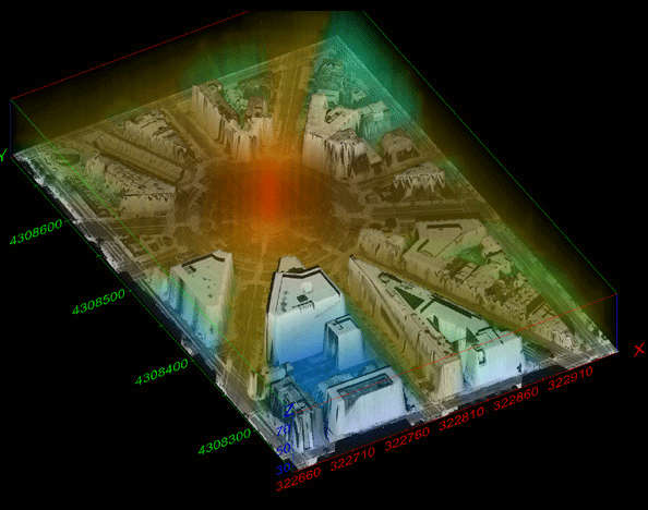
Model for a transmitter at the center of Dupont Circle in Washington, D.C. Three-dimensional field strengths displayed using volume rendering.
|
||||||||||||||||
The above model provided courtesy of the Institute for Telecommunication Sciences, which is the chief research and engineering arm of the U.S. Department Of Commerce National Telecommunications and Information Administration (NTIA). RF modeling software developed by ITS serves as a principal resource for solving the telecommunications concerns of other federal agencies, state and local governments, private corporations, associations, and international organizations.
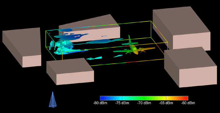
Illinois Institute of Technology Research Institute created the above electromagnetic multi-path model using Remcom's Wireless InSite software. The transmitter's location (left foreground) and the 5 buildings surrounding the study volume create a complex multi-path propagation scenario involving multiple diffractions and reflections. The visualization was performed in EVS-PRO to analyze and visualize signal power below -76.0 dBm and signal spread greater than 190 nanoseconds. Additionally, the aircraft is shown colored by the signal power on its skin. EVS provides a means to volumetrically identify regions within the model domain where the signal strength in conjunction with the signal spread would result in unacceptable reception. This methodology is being used within the Department of Defense and Intelligence Agencies to analyze RF propagation in urban environments. The technology is equally applicable to wireless companies that must optimize their use of the electromagnetic spectrum.
|