Now with improved performance and updated DEMS support
Transform your image files with unbeatable efficiency and accuracy. Geographic Transformer contains powerful raster transformation tools that allow you to georeference, reproject, tile and mosaic image files, all in a quick, easy-to-learn interface. In terms of efficiency, it?s hard to beat the Geographic Transformer. The tool also has great processing capabilities, allowing for ?batch? conversions intended for large transformation jobs.
Reprojection. The image reprojection capabilities are controlled by the Blue Marble geodata.xml, one of the most reliable and accurate geodetic datasource files in the market. The latest version enables the use of higher order math transformation models for true warping and accurate reprojection.
Geo-referencing Your Image. The Geographic Transformer allows you to easily establish an "image-to-world" relationship between image and map coordinates and reproject an image into a georeferenced image map. The tool has been in use since 1995 and was one of the first raster reprojection tools available for Windows. The application allows you to reference an image from either an existing reference file, or by using our popular ?point-and-click? method with an already referenced image. The tool essentially sets up a relationship between known control points and the associated pixels values of your image.
Geographic Transformer's Georeferencer
Extensive File Support. The Gegoraphic Transformer also has impressive file format support and cutting edge image file compression capabilities. Geographic Transformer supports all of the major raster data types used by GIS professionals including read and write of the three major compression formats ECW, JPG2000, and MrSID. Legacy Digital Elevation Model (DEM) and Digital Terrain Elevation Data (DTED) formats are also supported. Save your rasters out in whatever data type you need as a mosaic of multiple images or smaller tiled pieces from a larger image. The choice is yours!
What?s New? Version 6.3 comes with an optimized viewer and drawing functionality for faster loading and viewing of raster data. Batch processing for large jobs and projects have also been improved enabling quicker completion of large projects. DEM support has also been updated, including support for the Shuttle Radar Topography Mission (SRTM) height format.
Featuring MrSID write! Still the only raster tool available on the market that allows read and write to all of the major compressed image formats. Includes 500MBs of MrSID write free with purchase of the Geographic Transformer 6.3! More credits are available only through Blue Marble for a special discounted rate.
Other Features:
Dockable windows
Workspace settings that can be saved and shipped to other users
Administrative tools that can be used to lock down editing of the coordinate datasource to protect definitions and guide users
Complete FLEXnet licensing for easier porting of licenses and WAN usage
USB Dongle licensing
A datasource merge tool
The ability to transform between any datum (not just WGS84) and much, much more.
Geographic Transformer
Now with improved performance and updated DEMS support
Features
Reference, Reproject, File Translate, Mosaic, and Tile Map Images
Supports (read and write) all of the major GIS raster and reference formats including standard GeoTIFF, Mapinfo Table (TAB) and ESRI World (TFW, WLD, JGW) referencing files, Windows Bitmap (BMP), LizardTech's MrSID, JPG2000, Enhanced Compressed Wavelet (ECW), and more.
Easy to use!
You don't have to be an image analyst to use the Transformer! A "common sense" interface and step-by-step "Getting Started Guide" jump starts your image map projects.
Powerful, easy-to-use interface provides visual control to geographic referencing, reprojection, tiling, mosaicking, and quality control processes. Enhanced viewers let the user see how their settings will affect their files. Point and click interfaces make setting up transformations easy.
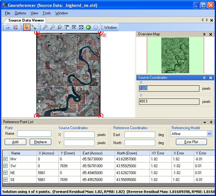
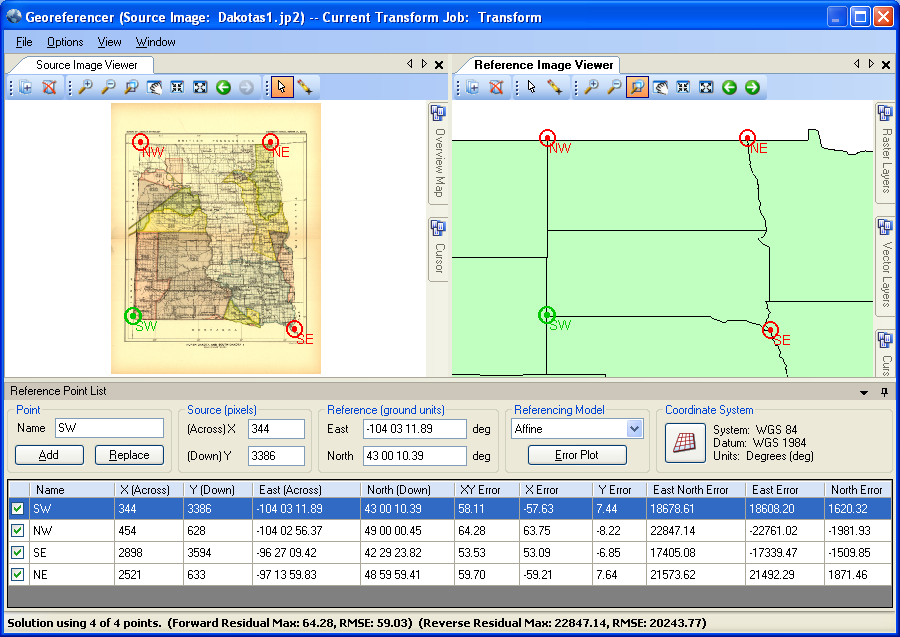
Georeferencing - Reference Point Selection
Georeferencing is accomplished by applying affine or first through fifth order polynomial models to the reference control point information. Interactively add, delete, and edit reference information to ensure an accurate fit.
Reference your images with a separate image viewer!
Easily georeference images by interactively selecting reference points.
Multiple view windows enable rapid reference point selection within source images.
Creates industry standard GeoTIFF, Mapinfo Table (TAB) and ESRI World (TFW, WLD, JGW) referencing files.
Transfer control points directly from your ArcView, MapInfo, AutoCAD, and MicroStation map files.
A production proven automatic reference point selection feature accelerates the registration of maps with regular grid lines.
DEM Transformations
The Transform job can process three-dimensional Digital Elevation Model (DEM) files like Digital Terrain Elevation Data (DTED) and USGS Spatial Data Transfer Standard (SDTS). The Transformer can also colorize and hillshade DEM datasets using customizable schemes.
Elevation Shader Configuration
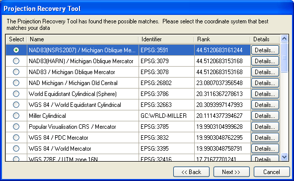
Projection Recovery Tool
This tool allows the user to assign coordinates to an image in the Georeferencer and perform projection recovery for unknown projections. If the reference coordinate system is not based on WGS 84, the tool can even transform through another datum before determining the unknown projection.
Projection Recovery Tool
Reprojection
Why would you want to reproject data with anything else? Transformer features the unmatched geodetic datasource of GeoCalc.XML. You can even define your own custom units, ellipsoids, datums and coordinate systems.
Specifically:
Over 3500 pre-defined coordinate systems
Over 165 ellipsoids
Over 630 datum transformations
Over 70 linear units and much more
Includes a batch processing interface for automated file processing!
Transformer allows users to create a batch job for transforming multiple images at one time. You can use the settings from other transform jobs or create a unique template from a batch job. Other batch capabilities include stringing together jobs of different types.
You have complete control over reprojection options!
Tiling and mosaicking
Automatically "cut" reprojected images into tiles. Enter column widths and row heights, specify the number of columns and rows to let Transformer calculate the width and height of the tiles, or set up custom tile parameters. The preview tab shows how the image will be tiled before the tiles are created. The tiling tools are flexible and allow users multiple naming options for every single tile. The custom tile tool allows you to hand draw the rectangles for exactly where you want the image tiled. You are no longer limited to a simple square or grid.
Use the Tile Settings tab to set up tiling parameters
Use the Tile Preview tab to preview and adjust tiling parameters
Create composite images by mosaicking individual image maps together. The cropping tool on mosaic jobs allows cropping of the input images as well as cropping of the final mosaic. There is also a mosaic preview viewer so you can preview your mosaic job prior to running it.
Use the Mosaic Settings tab to add files to the mosaic and set up its parameters
Quality Control
Use the enhanced viewer to provides immediate quality control of images with vector overlay.
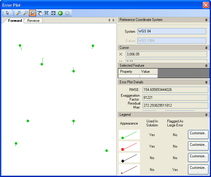
Assess registration accuracy by viewing a table or graph of residual errors.
View a graph of registration accuracy, you will know how accurately your images are georeferenced
The World's Most Comprehensive Coordinate Conversion Parameter Database
Over 12,000 coordinate system conversions are supported with pre-defined linear and angular units, ellipsoids, geodetic datums and coordinate systems. In addition, use our "two point fit" transformation and easy-to-use designers to create custom ellipsoids, datums, coordinate systems, and units.
Design your own coordinate systems
The Blue Marble Desktop
Geographic Transformer resides in the same desktop window as the Geographic Calculator. Work seamlessly with all of the features of both applications in a single interface through a combined license.
Blue Marble Desktop with Transformer
Compatibility
The Geographic Transformer uses open standards and is compatible with GeoTIFF specifications, ArcView, Arc/Info, MapInfo, MicroStation, AutoCAD, the USGS DRGs (Digital Raster Graphics) and DOQQs (Digital Orthophoto Quad standards).
Geographic Transformer
Now with improved performance and updated DEMS support
Details
Image Resampling Methods
(Provides different methods for displaying pixel values in output image.)
DTED Military Elevation (*.dt0, *.dt1, *.dt2, *.dt3, *.dt4, *.dt5)
USGS SDTS DEM (*.ddf)
USGS ASCII DEM (*.dem)
Supported Output Digital Elevation Model Formats
Arc/Info Ascii Grid (*.asc)
USGS ASCII DEM (*.dem)
Image Transformation Models
(Image pixel to reference coordinate system transformation.)
Affine (minimum three points)
1st Order Polynomial (minimum four points)
2nd Order Polynomial (minimum six points)
3rd Order Polynomial (minimum ten points)
4th Order Polynomial (minimum fifteen points)
5th Order Polynomial (minimum twenty-one points)
Coordinate Conversion Parameters
We include a comprehensive coordinate conversion parameter database that contains most common coordinate systems in use throughout the world. You can completely customize this file by adding or removing parameters. Currently, the coordinate conversion database contains:
Over 3500 pre-defined coordinate systems
Over 1200 datum shifts
Over 400 horizontal datums
Over 80 various unit definitions
14 prime meridians
A dozen vertical datums
Common coordinate systems included:
US State Plane 1927 (both original and exact solutions)
US State Plane 1983
UTM (Universal Transverse Mercator) North and South zones
Gauss-Kruger Modified, 3TM, and 6TM
XYZ Cartesian Eath-Centered Earth Fixed (ECEF)
New Zealand Map Grid
Grids for Argentina, Australia, Austria, Bahrain, Belgium, Borneo, Columbia, Cuba, Egypt, England, France, Ghana, Greece, India, Iraq, Ireland, Italy, Japan, Minnesota, Netherlands, New Brunswick, New Zealand, Nigeria, Peru, Phillipines, Qatar, Quebec, Rumania, Veracruz, and many more. More are being added all the time!
Map Projections
Aitoff
Alaska 27
Albers Equal Area
Azimuthal Equal Area
Azimuthal Equidistant
Behrmann
Belgium 72
Bipolar Oblique Conformal Conic
Bonne
Cassini
Craster Parabolic
Danish System 34
Danish System 34 1999
Double Stereographic
Eckert I
Eckert II
Eckert III
Eckert IV
Eckert V
Eckert VI
Egyseges Orszagos Vetulet
Equal Area Cylindrical
Equidistant Conic
Equidistant Cylindrical
European Stereographic
Fuller
Gall Stereographic
Gnomic
Goode Homolosine
Guam 27
Hammer Aitoff
Hotine Oblique Mercator
Hotine Oblique Mercator 1pt
Hotine Oblique Mercator 1pt Method2
IMW Polyconic
Krovak
Laborde
Lambert 27
Lambert Conformal Conic
Lambert Conformal Conic Extended
Lambert Tangent
Loximuthal
McBryde Thomas Flat Polar Quartic
Mercator
Military Grid Reference System
Miller Cylindrical
Mollweide
New Zealand Map Grid
Oblique Mercator Azimuth
Oblique Mercator Two Points
Orthographic
Perspective Conic
Polar Azimuthal Equal Area
Polar Equidistant
Polar Stereographic
Polyconic
Quartic Authalic
Robinson
Sinusoidal
Space Oblique Mercator
Stereographic
Stereographic 70
Swiss Oblique Mercator
Tilted Perspective
Times
Transverse Mercator
Transverse Mercator 27
Transverse Mercator Extended
Transverse Mercator Snyder
Transverse Mercator South Oriented
Two Point Fit
Universal Transverse Mercator
Van Der Grinten
Van Der Grinten IV
V and H
Vertical Perspective
Winkel I
Winkel II
Winkel Tripel
Datum Transformations
Molodensky
Bursa/Wolfe
DMA MRE
NADCON
HPGN
Canadian National Transformation V2
NAD27 to NAD83 Conversions
NAD27 to NAD83 conversions (or vice versa) with the United States and associated territories are performed using exactly the same algorithm and data files as used by the National Geodetic Service's NADCON program. Results are numerically identical to those of NADCON. Version 2.0 of the Canadian National Transformation is fully supported for conversion within Canada
NAD83 to HPGN Conversions
NAD83 to HPGN (NAD83/91 or HARN) conversions (or vice versa) are performed using the exact same algorithm and data files used by, and results are numerically identical to, the National Geodetic Service's NADCON program.
Compatibility
ArcView
ArcInfo
MapInfo
Microstation
AutoCAD DWG/DXF through R2000
other GIS and CAD systems that use raster images.
Geographic Transformer
Now with improved performance and updated DEMS support
Who's Using The Geographic Transformer
We have hundreds of thousands of customers and users around the world, here are just a few:
USGS
USDA
US Fish and Wildlife
NOAA
Google
Microsoft
ExxonMobil
British Geological Survey
Landmark
BP
Shell
Bechtel
Harvard University
Yale University
User Comments
"As ESRI and Microsoft developers, we work with a variety of software and applications. With our premier software package, ForestVIEW, we always include the Geographic Transformer. This product is fast, easy to learn, and very accurate. We wouldn't want to be without it."
J. Aschenbach - Vice President, Atterbury Consultants, Inc.
"Blue Marble Geographics has been listening at the watering hole. Blue Marble technical support is a refreshing experience. Upon contacting technical support, I got a real person with real answers - a definite plus in today's marketplace!"
J. Farley - University of Arkansas
"As a provider of Geographic Information Systems to the worldwide agribusiness community, AGRIS only recommends one image registration, rectification, and mosaicing tool...The Geographic Transformer by Blue Marble."
T. Pendleton -Executive Vice President, AGRIS Corporation
"The Transformer allowed us to georeference all the image formats in our dataset, quickly, easily and with astounding accuracy. It is an invaluable tool and one that we will use over and over again."
Phillipe Dovillez -IMAGIS Mediterranee
"I was impressed with the reprojection capability of the Geographic Transformer; for me, it's far easier and considerably faster than the ARC option."
Q: I'm not an image analyst or an image processing expert. Is the Geographic Transformer easy to use? A: Absolutely. There are even wizards to walk you through for each common task that you need to perform.
Q: Does the Geographic Transformer actually reproject an image when it creates an output transformed image? A: Yes. This is the most common question we are asked regarding the Geographic Transformer. The Transformer will reproject a source image into your specified destination coordinate system when creating a transformed image.
Q: Can I print out a graph with each of my reference points and any associated errors? A: Absolutely. We have included a complete charting package that even allows for graph customization.
Q: I have a referenced ArcView Shapefile. Can I transfer control points directly from it to an aerial photograph I am georeferencing? A: Absolutely. Simply display the Shape file in the reference map window and your aerial photographic in the source image window. Select the position of any point directly in the source image and reference map windows.
Q: How is creating an image map with the Geographic Transformer different than registering a raster image directly in MapInfo (ArcView or AutoCAD Map) with their raster image registration functions? A: The Geographic Transformer not only allows you to reference an image to a geographic coordinate system, it allows you to reproject a source image into a destination coordinate system. Adjacent images when viewed in MapInfo or other viewers will then appear to be seamless. This process is facilitated by the use of mathematical solution types: Affine, 1st-order Polynomial, and 2nd-order Polynomial.
Q: Can I create my own custom coordinate systems within the Geographic Transformer? A: Absolutely, the Geographic Transformer supports custom coordinate systems based on any supported datum, map projection, and unit. The Geographic Transformer provides a simple coordinate system designer that provides a simple interface for entering the required parameters for your custom coordinate system.
All coordinate system parameters are stored in an external coordinate conversion database, an ASCII file that can be shared between users and different Blue Marble applications.
Q: What is the format of an ESRI World File? A: The ESRI World File uses a six-parameter affine transformation to effect its image to world transformation where x' is the world coordinate of the pixel located at row x and column y:
1. y' is the world coordinate of the pixel located at row x and column y;
2. A is the x-scale or dimension of a pixel in world units in x direction;
3. B, D are rotation terms;
4. E is the negative of the y-scale or dimension of a pixel in world units in y direction assuming an upper left image origin with row values increasing downward; and
5. C, F are translation terms or the x and y world coordinates of the center of the upper left pixel.
The transformation parameters are in ASCII format (one per line) in the following order: A, D, B, E, C, F. The following is an example:
* Reference only - letters do not actually appear in the file.
Q: How do I determine the destination resolution when transforming an image? A: Destination resolution can be automatically calculated by simply clicking the Resolution button.
The "automatically" calculated value represents the resolution per pixel in the defined output coordinate system, and is equivalent to the resolution of the source image - which is typically desirable.
However, if you would like to use a different output resolution, the value may be manually calculated and entered into the resolution field.
For example, if you are transforming a 1:24,000 scale topographic map that was originally scanned at 250 dots per inch and you would like an equivalent resolution transformed image map you would calculate the destination resolution as follows:
Source Image Scale = 1:24000 or 1 inch = 2000 feet
Scanning Resolution = 250 dots per inch
Source Image Resolution = 2000' / 250 dots per inch = 8 feet per pixel
Destination Resolution = Source Image Resolution = 8 feet per pixel.
Q: What is the format of the Blue Marble referencing file (.RSF)? A: The first line contains the version of the file format, not to be confused with the version of the software, and the total number of points in the file. The remaining lines contain, in each line, the point ID, the x (row) pixel, the y (column) pixel, the z (elevation) value which is usually 0.00 followed by the ground coordinates expressed as Latitude or Northing (Y), Longitude or Easting (X) and Elevation (Z). The last value indicates whether the point described on that line is included in the solution, 0 = not included and 1 = included. Here is an example:
Q: How do you user-define an Albers Equal Area coordinate system? A: Select Options/View Coordinate System Definitions. Select new group, give it a unique name (i.e.. Albers). Select new system, once again selecting a name. Under projection, select Albers Equal Area conic. The values should be in the following order: origin longitude, origin latitude, southern parallel, northern parallel, false northing, and false easting. Simply substitute the appropriate numbers into the appropriate slots. Select save and you are ready to use your user-defined coordinate system. The database can be extended to support an unlimited number of user-defined coordinate systems.
Q: Can I produce a set of orthophotos that are much smaller in file size than the original photographs? A: Yes. If you are interested in cutting the orthophotos into smaller pieces for display, the Geographic Transformer will allow you to tile the destination image into fixed sized pieces automatically.
Q: What resampling technique does the Geographic Transformer use when reprojecting an image? A: The Geographic Transformer uses the nearest neighbor resampling technique. The primary reason is to preserve uniform color depth (palette colors) between the input and output images. This is important due to the fact that other resampling techniques may cause an increase in colors (e.g. 16 to 256, or 256 to several million) thus enlarging the output file size drastically.
Q: Does the Geographic Transformer support the HARN/HPGN datum transformation method? What is the HARN/HPGN method? A: Yes. The Geographic Transformer fully supports HARN/HPGN, and uses grid files in a format published and provided by the National Geodetic Survey.
HARN is an acronym for High Accuracy Reference Network, and HPGN is an acronym for High Precision Geodetic Network. These systems are designations used for statewide geodetic network upgrades. HARN is generally used to refer to either system. This upgrade is an improvement to the accuracy of NAD 83 datum, and is most frequently used with the State Plane 1983 Coordinate Group and systems. The HARN datum use GPS (Global Positioning System) observations that are the basis of grid shift files. In GeoCalc (the coordinate conversion engine within the Geographic Transformer), these grid shift files are incorporated in to datum, and referenced during coordinate transformations.
HARNs are being established within the U.S. on a state-by-state basis by the National Geodetic Survey. HARNs have been established for 28 states and Puerto Rico and the Virgin Islands: Alabama, Arizona, California, Colorado, Florida, Idaho-Montana, Kentucky, Louisiana, Maine, Maryland-Delaware, Michigan, Mississippi, Nebraska, New England (CT, VT, MA and RI), New Mexico, Oklahoma, Tennessee, Texas, Virginia, Washington-Oregon, Wisconsin and Wyoming.
You can think of a HARN as a geodetic datum, most easily viewed as an enhanced NAD 83 datum. HARNs are also known as NAD 83/91 and High Precision Grid Networks (HPGN). The NGS HARN method is actually very similar to the NGS NADCON method. As with the NADCON method the shift values for a geographic area are stored in a set of grid files, one representing latitude shifts (named with the extension .las) and one representing longitude shifts (named with the extension .los). The major difference is that the HARN data files contain shifts from NAD 83 to a HARN instead of NAD 27 to NAD 83.
Q: What is the NADCON Datum Transformation method? Can I use this method with the Geographic Transformer? A: The NADCON method transforms coordinate values between the North American Datum of 1927 (NAD 27) and the North American Datum of 1983 (NAD 83). The NGS NADCON method provides a transformation that is accurate to within 0.15-0.5 meters and is highly recommended for NAD27 and NAD83 conversions within the U.S. and other territories. The NGS NADCON method applies a simple interpolation algorithm using a gridded set of standard datum shifts as parameters. The shift values for a geographic area are stored in a set of grid files, one representing latitude shifts (named with the extension .las) and one representing longitude shifts (named with the extension .los). The Geographic Transformer fully supports this method, and uses grid files in a format published and provided by the National Geodetic Survey.
Q: Does the Geographic Transformer support GeoTIFF? A: Absolutely, the Geographic Transformer will read and write referencing and coordinate system information directly to/from GeoTIFF images.
Q: How do I evaluate the Geographic Transformer? A: You can completely evaluate version 4.x, including image reprojection, with any ONE of your own images, or with any of the sample images provided within the new, enhanced Getting Started Guides.
Q: How do I transfer my floating license from one computer to another? A: You will find step by step instructions for doing this in our 'Installing and Configuring the Floating License' White Paper found here.


 Geographic Transformer's Georeferencer